
Earth Changes · Daily Report · September 28, 2026
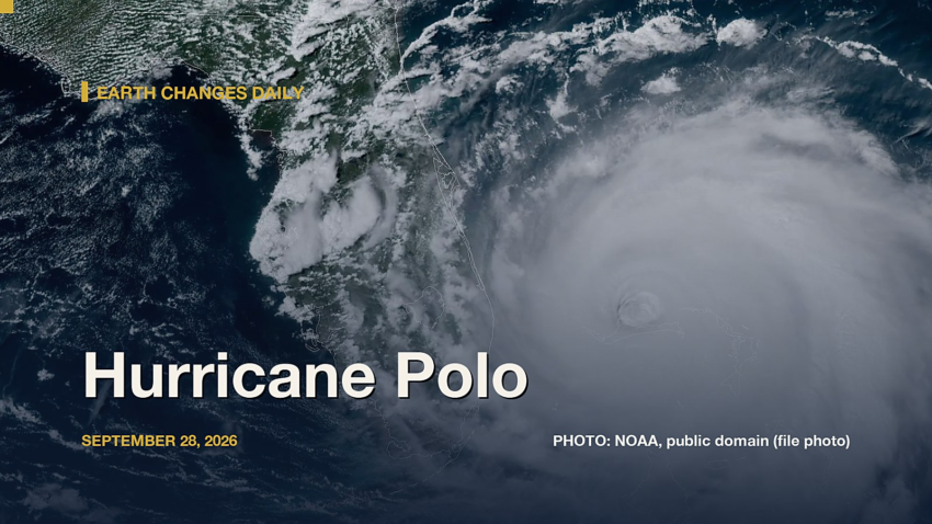
Hurricane Polo is churning in the eastern Pacific with top winds near 115 mph and a central pressure of 963 millibars, moving northeast at 13 mph, according to the National Hurricane Center.[1] “Polo is about to make landfall on Baja California Sur,” forecaster Cangialosi wrote.[2] It is one of 5 tropical systems the center is tracking, along with Hurricane Nolo, Tropical Storm Rachel, Tropical Storm Hanna and Tropical Storm Fay.
Meanwhile, the National Weather Service has 46 severe or extreme alerts in effect, led by 35 flood watches across AZ, CA, CO, IA and more.[3]
Elsewhere, a magnitude 5.4 earthquake struck north of Svalbard at 1:22 p.m. UTC on Sept. 28, about 10 km (≈6 miles) below the surface, the U.S. Geological Survey reports[4]. The USGS PAGER system rates the expected impact GREEN. It was one of 21 quakes of magnitude 4.5 or greater in the past day.
Today at a Glance
- 21 earthquakes of magnitude 4.5 or greater, the largest M5.4
- 5 active tropical systems: Hurricane Nolo, Hurricane Polo, Tropical Storm Rachel, Tropical Storm Hanna, Tropical Storm Fay
- 46 severe or extreme U.S. weather alerts
- 4 U.S. volcanoes above normal, including Great Sitkin, Kilauea
- 3 sinkhole reports in the news
Where It’s Happening
Numbered pins match the list under the map. Storm and quake pins are the agencies' reported centers; sinkhole pins mark the town named in the report. Map data: OpenStreetMap contributors.
1. Extreme Weather
Tropical storms and hurricanes
- Hurricane Nolo (eastern Pacific): top winds near 125 mph, moving northwest at 13 mph. Latest advisory.[1]
- Hurricane Polo (eastern Pacific): top winds near 115 mph, moving northeast at 13 mph. Latest advisory.[1]
- Tropical Storm Rachel (eastern Pacific): top winds near 60 mph, moving west-northwest at 10 mph. Latest advisory.[1]
- Tropical Storm Hanna (Atlantic): top winds near 45 mph, moving east-southeast at 14 mph. Latest advisory.[1]
- Tropical Storm Fay (Atlantic): top winds near 40 mph, moving southwest at 10 mph. Latest advisory.[1]
Across the United States, the National Weather Service has 46 alerts rated severe or extreme in effect.[3]
| Alert | Number | States |
|---|---|---|
| Flood Watch | 35 | AZ, CA, CO, IA, KS, MN and more |
| Flash Flood Warning | 5 | AZ, CA, NV, UT |
| Flood Warning | 4 | FL, IA, IL, MA |
| Coastal Flood Warning | 1 | FL |
| High Wind Warning | 1 | MT |
The Storm Prediction Center says its highest risk level for severe thunderstorms today is marginal, on a scale that runs marginal, slight, enhanced, moderate, high.[5]
Around the world, GDACS logged 62 wildfire, 4 flood, 2 tropical cyclone, 1 volcano notices in the past two days, all at its lowest (Green) level.[6]
Video: Associated Press, September 28, 2026 — “Fishing town in Mexico braces for Hurricane Polo as flood fears grow”. Matched to this report by the storm, volcano or place name in its title.
Video: TRT World, Turkey's public English-language broadcaster, verified Telegram channel, September 28, 2026 — “Torrential rains inundated Bangkok, swamping roadways and submerging vehicles across the Thai capital. Authorities declared the capital a disaster-affected area on September 26, and by September 28, reported that approxi” Topic: flood. Picked by hazard keywords in the channel’s own caption. Telegram only plays this file in its app: use the button above.
2. Earthquakes
The USGS recorded 21 earthquakes of magnitude 4.5 or greater in the past 24 hours.[7] The strongest:
| Mag. | Where | When | Depth | PAGER |
|---|---|---|---|---|
| 5.4 | north of Svalbard | Sept. 28, 1:22 p.m. UTC | 10 km | GREEN |
| 5.4 | 231 km WSW of Port McNeill, Canada | Sept. 28, 4:41 a.m. UTC | 10 km | GREEN |
| 5.3 | 60 km NE of Tadine, New Caledonia | Sept. 28, 3:25 a.m. UTC | 10 km | — |
| 5.2 | 190 km WSW of Port McNeill, Canada | Sept. 28, 9:13 a.m. UTC | 10 km | — |
| 5.2 | 67 km ENE of Tadine, New Caledonia | Sept. 28, 5:45 a.m. UTC | 10 km | — |
| 5.1 | 78 km ENE of Tadine, New Caledonia | Sept. 28, 5:28 a.m. UTC | 10 km | — |
| 5.1 | South Sandwich Islands region | Sept. 28, 3:43 a.m. UTC | 35 km | — |
| 4.9 | 2 km SW of Sakai, Japan | Sept. 28, 7:45 p.m. UTC | 71 km | — |
PAGER is the USGS estimate of likely deaths and damage: GREEN means little or none expected, RED means extensive. A dash means none was issued.
3. Volcanoes
In the United States, 4 volcanoes are above normal background activity, according to the U.S. Geological Survey’s observatories:
| Volcano | Alert / aviation code | Latest word from scientists |
|---|---|---|
| Great Sitkin | Watch / Orange | Slow eruption of lava within the summit crater continues.[8] |
| Kilauea | Watch / Orange | Small overflows from the north vent continue within Halema'uma'u crater at the summit of Kīlauea. All vents have strong glow and intermittent spatter. There is no anomalous activity outside of the summit.[9] |
| Ahyi Seamount | Advisory / Yellow | No plumes seen in satellite images; no significant geophysical signals.[10] |
| Shishaldin | Advisory / Yellow | Low-level unrest continues.[8] |
Alert levels run Normal, Advisory, Watch, Warning. Aviation codes run Green, Yellow, Orange, Red.
4. Sinkholes
No government agency publishes a live national sinkhole feed, so these come from today’s local news:
- Naperville: NCTV17 reports, “Westbound traffic on 95th Street in Naperville is reduced to one lane through the intersection at Book Road as crews monitor a now-filled sinkhole that opened around 5 p.m. on Sunday, Sept. 27.”[11]
- Belmont: WHDH reports, “A car fell into a sinkhole in Belmont on Sunday morning.”[12]
- CBS7 reports, “The Pecos County Sheriff’s Office says Highway 1053 will be closed Wednesday due to a sinkhole.”[13]
Also in the News
Other natural-hazard video from the past day, from news organizations:
Video: NBC News, September 29, 2026 — “Deadly storm slams East Coast”. Also in the news. Picked because its title names a natural hazard; it may not be covered in the data above.
Video: AccuWeather, September 28, 2026 — “Tracking the Southwest Flood Threat: What You Need to Know”. Also in the news. Picked because its title names a natural hazard; it may not be covered in the data above.
5. What the Experts Say
These are the words of the scientists and forecasters who watch these hazards for a living, quoted exactly.
“The current forward motion of the hurricane is 315/11 kt, as the cyclone continues to turn in response to an upper level trough located to its northwest. A general northward motion is expected through tomorrow. Thereafter, the upper level trough is expected to merge with the hurricane. This will dramatically slow Nolo's forward motion as it approaches the islands of the Papahanaumokuakea National Monument. Later this week, a ridge is forecast to build northwest of Nolo and begin to steer the system westward and nearly parallel to the northwestern Hawaiian Islands within the monument. The track forecast is largely an update of the previous one, follows the latest HCCA and GDM guidance, and attempts to reconcile the many complicated steering features.”
— Forecaster Mahoney, National Hurricane Center, on Hurricane Nolo[14]
“Polo is about to make landfall on Baja California Sur. Heavy rains and hurricane-force winds have already spread across the peninsula, and the worst conditions will likely occur in the hurricane warning area within the next few hours. Polo is not as well organized as it was earlier, with the eye filling in satellite images. The initial intensity is held at 100 kt near the high end of the latest satellite estimates, but this could be a little generous.”
— Forecaster Cangialosi, National Hurricane Center, on Hurricane Polo[2]
“Isolated strong to locally severe storms remain possible this evening across parts of the western/central Dakotas and also the central High Plains.”
— Forecaster Dean, NOAA Storm Prediction Center[5]
“Earthquake activity was quiet over the past day. Steaming from the summit area was observed in satellite images. Clouds obscured web camera views.”
— Alaska Volcano Observatory, on Great Sitkin[8]
“Episode 55 remains a possibility during the ongoing Kīlauea summit eruption. Precursory overflows from the north vent resumed on the night of September 22 and continue this morning. The south vent also produced a few very small overflows yesterday.”
— Hawaiian Volcano Observatory, on Kilauea[9]
“Sinkholes are common where the rock below the land surface is limestone, carbonate rock, salt beds, or other rocks that can naturally be dissolved by groundwater circulating through them. As the rock dissolves, spaces and caverns develop underground. Sinkholes are dramatic because the land usually stays intact for a while until the underground spaces just get too big.”
— U.S. Geological Survey Water Science School, on why sinkholes form[15]
How to Prepare
- Keep a basic kit: water (one gallon per person per day for several days), food, a battery or hand-crank radio, a whistle, a dust mask and phone chargers.[16]
- Get alerts: Wireless Emergency Alerts need no sign-up; the FEMA app, NOAA Weather Radio, the USGS Earthquake Notification Service and the USGS Volcano Notification Service are free.
- Floods: Turn Around, Don’t Drown. Six inches of moving water can knock you down, and one foot can sweep a car away.[17]
- Earthquakes: Drop, Cover and Hold On.[18]
- Download the checklist: Be Ready: Earthquakes, Volcanoes, Extreme Weather and Sinkholes (PDF), with today’s active hazards first.
How to Verify This Yourself
- Earthquakes: USGS Latest Earthquakes map
- U.S. volcanoes: USGS Volcano Hazards Program; world: Smithsonian weekly report
- Weather alerts: weather.gov; tropics: nhc.noaa.gov
- Worldwide disasters: gdacs.org
References
- National Hurricane Center, active storms data nhc.noaa.gov. ↩
- National Hurricane Center, Polo forecast discussion nhc.noaa.gov. ↩
- National Weather Service, active alerts API api.weather.gov. ↩
- USGS, M5.4 north of Svalbard event page earthquake.usgs.gov. ↩
- NOAA Storm Prediction Center, Day 1 Convective Outlook spc.noaa.gov. ↩
- GDACS, Global Disaster Alert and Coordination System gdacs.org. ↩
- USGS, M4.5+ earthquakes, past day (real-time feed) earthquake.usgs.gov. ↩
- Alaska Volcano Observatory, Great Sitkin notice volcanoes.usgs.gov. ↩
- Hawaiian Volcano Observatory, Kilauea notice volcanoes.usgs.gov. ↩
- Northern Mariana Islands, Ahyi Seamount notice volcanoes.usgs.gov. ↩
- NCTV17, Crews repair sinkhole on 95th Street in Naperville nctv17.org. ↩
- WHDH, Crews respond after car falls into sinkhole in Belmont whdh.com. ↩
- CBS7, Highway 1053 to close at the Sinkhole near Fort Stockton Wednesday for repairs firstalert7.com. ↩
- National Hurricane Center, Nolo forecast discussion nhc.noaa.gov. ↩
- USGS Water Science School, Sinkholes usgs.gov. ↩
- Ready.gov (FEMA), Build a Kit ready.gov. ↩
- Ready.gov (FEMA), Floods ready.gov. ↩
- Ready.gov (FEMA), Earthquakes ready.gov. ↩
Methodology: this report is assembled automatically each morning from the live data feeds of the USGS, the Smithsonian Global Volcanism Program, the National Weather Service, the National Hurricane Center, the Storm Prediction Center and GDACS, plus same-day news reports for sinkholes. No AI writes it: the sentences are fixed templates filled with that data, and every quote is copied exactly from the source it is credited to. Data can change after publication; follow the links for the latest.

Kemetic Minds Editorial Desk
Verified NewsroomPrimary-sourced investigative intelligence on civil rights, voting rights, federal policy, and consumer protection. Sourced from primary legal filings, government statistics, and direct field reporting.